Recently Neptune Energy drilled the 6407/8-8 S Calypso well in the Norwegian sea. The well has been drilled using the Deepsea Yantai, a semi-submersible rig up to the depth of 3496 meters in the Garn formation, a sandstone reservoir in the middle and lower Jurassic formation.
6407/8-8 S Calypso is located at ED-50 coordinates of 64° 24'36.9952" N and 7° 31'21.1425" E. The Calypso prospect is located 14 km northwest of the Draugen field and 22 km northeast of the Njord A platform, within the Neptune-operated PL938 License.
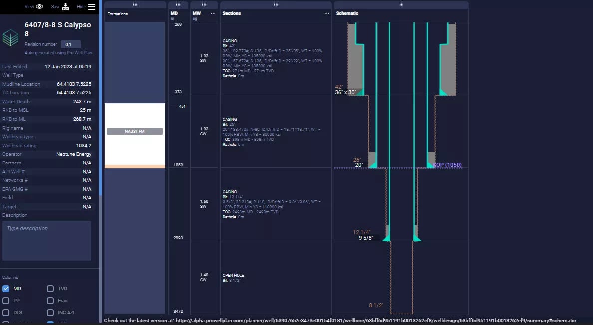
An overview of the hole sections is described shortly here.
9-7/8" Pilot Hole
9-7/8” pilot hole was drilled from seabed at 298.3 meters up to 1045 meters from RKB using 1.03 sg seawater as drilling fluid.
42"x36” Section
42"x36" hole was drilled using seawater and 36"x30" conductor casing was set at 373 meters.
26” Section
26" section was drilled up to the depth of 1045 meters with seawater as drilling fluid. According to offset data available in Pro Well Plan through NPD, the formation drilled in this section might be the Naust formation in the Nordland Group. 20" casing (N-80, 133 lb/ft) was run up to the section bottom and cemented with the top of cement almost 150 meters above the shoe.
17-1/2” Section (Contingent Section)
A contingent 17-1/2” section was planned to be drilled from seabed up to 1,950 meters using a maximum of 1.4 sg oil base mud. 13-3/8" casing was planned to be run if required.
12-1/4” Section
12-1/4” section was planned to the top of the reservoir at section TD of 2855 meters using 1.6 sg oil base mud. 9-5/8" casing (P-110, 53.5 ppf) was planned to run up to the section depth with the top of cement 400 meters above the shoe.
8-1/2” Section
The main wellbore was planned to be completed in 8-1/2” open hole up to the depth of 3501 meters in the Garn Formation, using 1.4 sg oil base mud. A contingent 7" liner was also planned with further drilling of a 6" hole as contingent, in case of failure to reach the target with the previous casing.
Sidetrack
Two sidetracks were planned for data gathering. The first one was planned at around 1050 meters in 20" casing or 13-3/8" casing. Before this sidetrack, 9-5/8" casing was to be cut and removed. Then 12-1/4" section was planned to drill down to the depth of 2849 meters using oil base mud. 9-5/8" casing was planned to be run and cemented with the top of cement 400 meters above the shoe. 8-1/2" open hole was planned down to the depth of 3485 meters using oil base mud.
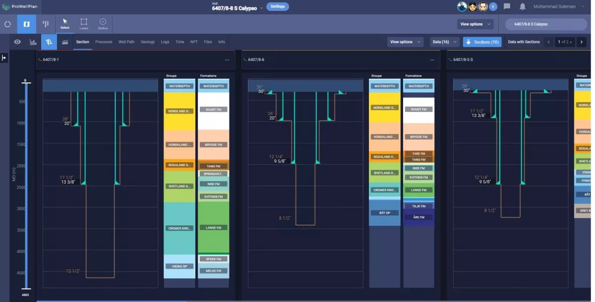
Visual Comparison of geology, section depths, and casing properties can be easily performed using the explorer panel in PWP. Moreover, all of this data can be imported to the current well with a single click and adjusted to new parameters.
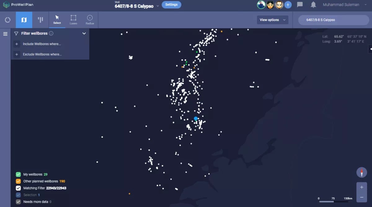
A design for 6407/8-8 S has been created in Pro Well Plan using its coordinates. Its location on the map gives all the relevant data of nearby wellbores. Each dot on the map represents a wellbore and it is super easy to visualize and compare their data.
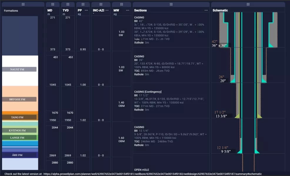
Casing Data
Casing data along with hole sizes, mud weights, and geological formations can be easily compared in the Comparison Tab. Access to such data with a single click gives immense power to drilling engineers to make decisions with full confidence.
Well Paths Data
Well paths of nearby wellbores give crucial information about their extent and depth. This data can be combined with the logs and the geologies to access possible risks associated with an exploration well.
.webp?width=1200&height=602&name=Well-Paths_fd580bade3f2732bbaa01b4c46b49104%20(1).webp)
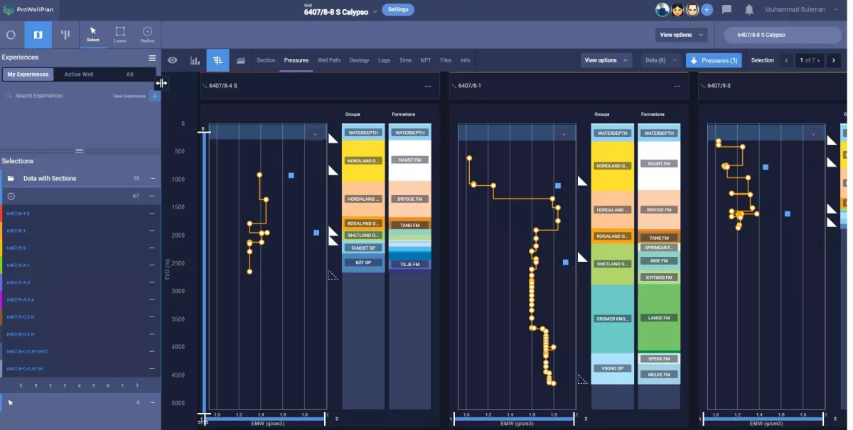
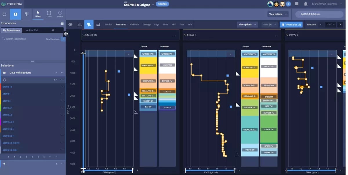
Pressures Data
The pressure data includes pore pressures, fracture pressures, and mud weights. For an exploration well, such data is always uncertain. Using Pro Well Plan, drilling engineers can look at hundreds of nearby wellbores with their pressure data available for comparison with a single click.
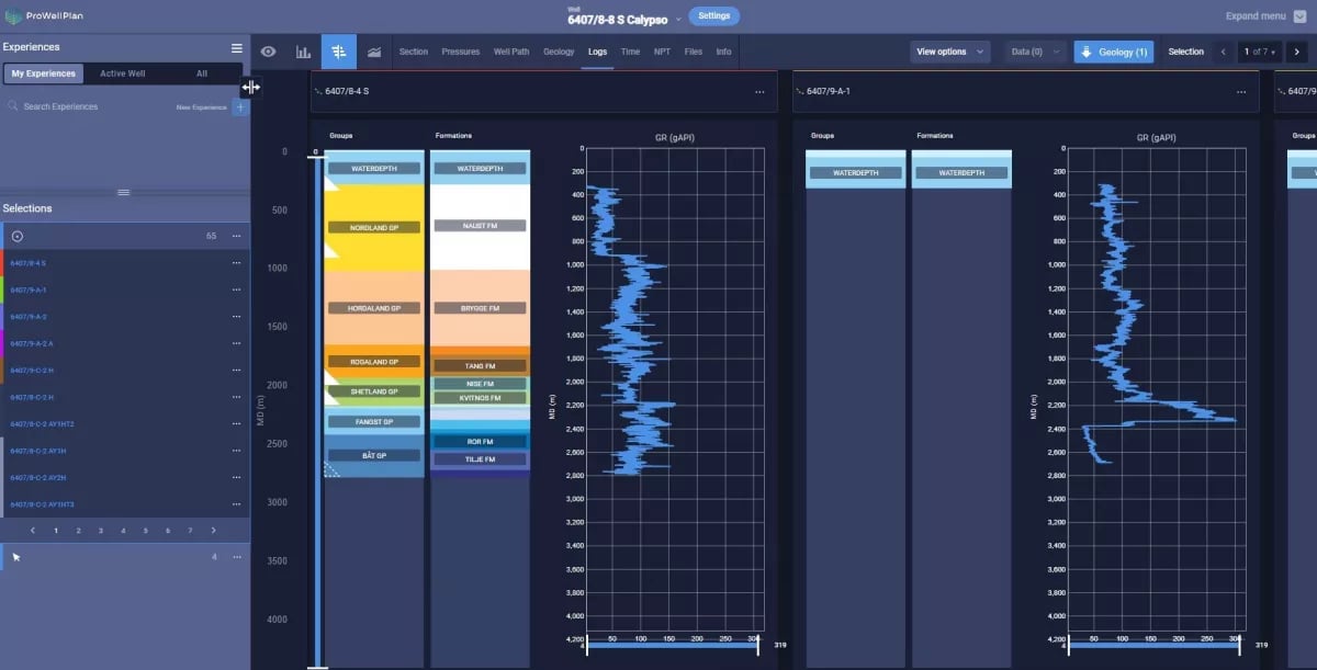
Logs Data
The drilling logs are crucial for an exploration well as they provide detailed information about the geological formations encountered while drilling. This information is used to determine hydrocarbon presence and plan further drilling operations. Drilling logs also provide information on the mechanical integrity of the well and can be used to detect and prevent potential problems.
Pro Well Plan has digitalized logs for easy analysis and quick comparison.
Here is how offset analysis for an exploration well can be done efficiently using data from several sources, all in one place - Pro Well Plan.
Get in contact with us to unleash new opportunities with PWP software!